
EDITORIAL
Some Red Flags
![]() about
Burlington’s Strategic Program for Comprehensive Flood Hazard Mitigation FEIS
about
Burlington’s Strategic Program for Comprehensive Flood Hazard Mitigation FEIS
"They must find it difficult - Those who have taken authority as the truth, rather than truth as the authority." -Gerald Massey (1828-1907)[1]
When the Skagit County Board of County Commissioners asked me to
serve on the Skagit County Flood Control Zone District Advisory Committee, I
told them that there were two things I brought to the table. One was my
documentation of the history of the flood issue
![]() and
the other was my experience with the 1979 Levee Improvement Project (1979
Levee Improvement Project Historical Index). One of my goals was to
try and make sure we did not go down the same path we went in the 1970’s and end
up with a 71.4% voter rejection at the polls. (Source:
11/7/79 SVH)
I’m a strict floodplain management advocate, meaning that only farmers belong in
floodplains. I also wanted to make sure that no proposed project would promote
more development in the floodplain. I realize of course that Mt. Vernon and
Burlington have raced with each other to sprawl their cities into the
surrounding flood-prone farmland and now need to focus on reducing the risk
level inherent in their poor planning practices in order to promote more of the
same. Most importantly, I firmly believe that before any sales or property tax
revenues is proposed to pay for a flood control project, the voters must be
allowed to approve or disapprove of said expenditure.
and
the other was my experience with the 1979 Levee Improvement Project (1979
Levee Improvement Project Historical Index). One of my goals was to
try and make sure we did not go down the same path we went in the 1970’s and end
up with a 71.4% voter rejection at the polls. (Source:
11/7/79 SVH)
I’m a strict floodplain management advocate, meaning that only farmers belong in
floodplains. I also wanted to make sure that no proposed project would promote
more development in the floodplain. I realize of course that Mt. Vernon and
Burlington have raced with each other to sprawl their cities into the
surrounding flood-prone farmland and now need to focus on reducing the risk
level inherent in their poor planning practices in order to promote more of the
same. Most importantly, I firmly believe that before any sales or property tax
revenues is proposed to pay for a flood control project, the voters must be
allowed to approve or disapprove of said expenditure.
![]()
On February 13, 2009, Burlington issued a Draft Environmental Impact Statement (“DEIS”) on its “Strategic Program for Comprehensive Flood Hazard Mitigation” program. (Draft Environmental Impact Statement). Government agencies and citizens were encouraged to comment. Seventeen months later on July 16, 2010, the City issued its Final Environmental Impact Statement/FEIS To Adopt A Strategic Program for Comprehensive Flood Hazard Mitigation. Sadly, there were only 15 comment letters submitted, (Citizens 6; Hospitals 1; Developers Attorney 1; County government 1; Federal government 1; State government 1; Tribes 1; Dike Districts 2; Citizen Groups 1) the majority of which were not even from Burlington residents, and the majority of comments were completely ignored by the City staffers and consultants.
Unfortunately, I feel that Burlington’s FEIS is taking us down the same path as 1979, and once again, – whether through ignorance or contempt for the voting public -- the Burlington City staff and some of their private consultants have doomed any countywide effort to failure. Perhaps this is because none of the contributing city staffers was here in 1979 or even lives in Burlington City limits for that matter or even worse, they just don’t care. Given the history that was made available to them their document and the verbiage it contains is inexcusable.
There are way too many red flags, falsifications, misstatements and misrepresentations to address them all in one editorial. My original letter on the DEIS was 20 pages and took a great deal of time and effort to prepare, so given the fact that the majority of the information was ignored and/or misrepresented in the FEIS it would serve little to point out every single thing that was wrong with the FEIS. (March 2009 Angry Citizen: Comments on Burlington Draft Environmental Impact Statement.) Therefore, just a few red flags should suffice:
![]() #1.
The City of Burlington (City) is a fully
developed city located in Skagit County, at the intersection of Interstate 5 and
State Route 20 and on the mainline of the BNSF Railroad.
Over 3.5 million square
feet of commercial and industrial construction
and over 1400 dwelling units have been built
between 1995 and 2008, based on the Flood Insurance Rate Map
(FIRM) adopted in 1985.
(Source: FEIS page 6)
#1.
The City of Burlington (City) is a fully
developed city located in Skagit County, at the intersection of Interstate 5 and
State Route 20 and on the mainline of the BNSF Railroad.
Over 3.5 million square
feet of commercial and industrial construction
and over 1400 dwelling units have been built
between 1995 and 2008, based on the Flood Insurance Rate Map
(FIRM) adopted in 1985.
(Source: FEIS page 6)
This speaks volumes about not only the irresponsible land use planning of the City Planning and Building Department, but goes to the effectiveness of the FIRM adopted in 1985. The FIRM did not slow or prohibit growth in an area with a long history of flooding but enabled and promoted growth by providing flood insurance through the NFIP. Nevertheless, it is nice to finally see the City Planning Department publically admitting to recklessly endangering “over 1,400” newly-arrived families over the course of the past fifteen years.
![]() #2.
To the extent practicable, it is
the intention of the City of Burlington and Dike District #12 to
minimize upstream and downstream impacts
on existing conditions, while maintaining or enhancing current levels of flood
protection and achieving FEMA accreditation of a segment of Dike District #12’s
levee system.
(Source: FEIS page 6)
#2.
To the extent practicable, it is
the intention of the City of Burlington and Dike District #12 to
minimize upstream and downstream impacts
on existing conditions, while maintaining or enhancing current levels of flood
protection and achieving FEMA accreditation of a segment of Dike District #12’s
levee system.
(Source: FEIS page 6)
Burlington already knows exactly how much its current “existing conditions” levee system impacts upstream property owners. See the graphic below:
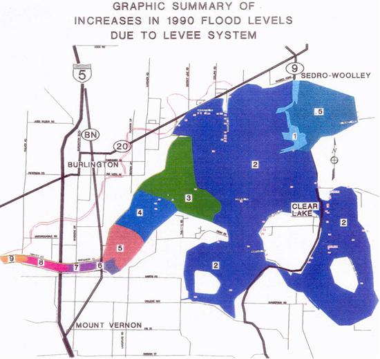
This hydraulic study of the impacts of the Burlington “levee system” shows that during the 1990 and 1995 flood events the amount of water “induced and artificially stored” on upstream property owners is anywhere from ½ foot at the Sedro-Woolley Sewage Treatment Plant to 4 feet upstream of the BNSF Railway Bridge, to 8+ feet in the 3 bridge corridor. By using verbiage like “to the extent possible”, Burlington is admitting that they know that raising the levees will have adverse impacts on upstream property owners. As page 22 of the DEIS so aptly put To gain the required three feet of freeboard under any hydrology and hydraulic scenario that is currently on the table, a range of between two and five feet of additional levee height will be required. Three to five feet cannot help but aggravate an already intolerable situation. How anyone could sleep at night knowingly putting their floodwater into others homes and businesses is beyond me. The ugly fact of the matter is that the Burlington City Staff simply doesn’t care about the manner or extent of the harm their plan will cause to their upstream and downstream neighbors.
![]() #3.
Given the known flood risk, it is
essential that the City and Dike District #12 move forward to reduce this risk.
The City and Dike District #12 have a responsibility and an obligation to
protect Burlington, which is why these entities are embarking on the proposed
actions prior to the completion of the regional planning effort.
(Source: FEIS page 7)
#3.
Given the known flood risk, it is
essential that the City and Dike District #12 move forward to reduce this risk.
The City and Dike District #12 have a responsibility and an obligation to
protect Burlington, which is why these entities are embarking on the proposed
actions prior to the completion of the regional planning effort.
(Source: FEIS page 7)
Given the known flood risk which presumably the City has known since 1897 and at a minimum since through its own admission the 1985 FIRM referenced above, wouldn’t it have been more prudent to have limited commercial and residential development to keep people and commercial establishments out of harm’s way? If we reward stupidity, doesn’t that simply encourage more stupidity?
As I have said on many prior occasions, rivers and their floods do not cause damages. However, building a city on the bottom of a river’s floodway does cause damages. Once again, it is nice to see that Burlington had knowledge of the “known flood risk” and must have decided that the risk was worth taking to allow “Over 3.5 million square feet of commercial and industrial construction and over 1400 dwelling units have been built between 1995 and 2008.” But most shocking about the above statement is that Burlington is announcing pretty much “The hell with the rest of Skagit County, we’ll do whatever we want to do.” What this means is that if Burlington and Mt. Vernon are taken out of the 100 year floodplain, all the time and money that has been spent on the Corps of Engineers GI Study will be for naught because without Burlington and Mt. Vernon there is insufficient cost to benefit ratio for projects to protect all the other floodplain residents. The public should raise their taxes to pay for this why?? The Burlington City government doesn’t seem to care about anyone but itself.
![]() #4.
The 1984 Flood Insurance Study stated “…for the Skagit River proper,
the levees confining the channel
and adjacent areas have been designated as
floodways,” using the most landward levees to establish the floodway
boundary.
(Source: FEIS page 12) In addition,
FEMA
#4.
The 1984 Flood Insurance Study stated “…for the Skagit River proper,
the levees confining the channel
and adjacent areas have been designated as
floodways,” using the most landward levees to establish the floodway
boundary.
(Source: FEIS page 12) In addition,
FEMA
included as floodway, areas lying within 300 feet of the landward toe of the levee. (Source: FEIS page 13)
So Burlington after all these years finally admits that the levees were designated as floodways along with adjacent areas, although with no FEMA documentation to support the statement they state Floodways in Burlington consist of all areas riverward of the riverward toe of dikes and levees along the Skagit River.” (Source: FEIS page 12) That statement is just untrue. As such, fill is prohibited in the floodways, meaning that all the “improvements” as in adding 2 to 5 feet of fill to the current levees would be prohibited. In addition, what Burlington has not stated is that the Dike District filled large portions of the 300 feet with fill in an attempt to provide a “back slope” to allow for overtopping. Of course, there were no permits obtained for such activity nor any correspondence with FEMA produced to get their blessing to fill the floodway. While I applaud the activity of the Dike District to provide for the back slope with respect to overtopping, there should have been permits issued for such activity and FEMA should have been consulted in order that local property owners would realize that the floodway had been moved.
The most galling aspect of all this is that the City of Burlington knew full well the extent of the problem they were creating. At a public hearing in 1984, the City Council was told by their City Planner the following:
And lastly there is the FLOODWAY which in the case of Burlington is only the area that runs landward of the dike by fifty feet. When you’re landward of the dike and you’re looking towards the river essentially nothing can be built from that distance to the river. (Source: Transcript of Burlington City Council Meeting November 8, 1984)
FEMA’s Washington DC Office informed the City of Burlington that the levees were designated as floodways in 1984.
Thus, only lands within and including the Skagit River levees were designated as floodways in the conventional manner. (Source: FEMA letter dated 2/1/84 to Mayor Ray Henrey )
![]() #5.
The August 2005 City of Burlington’s Updated Surface Water Management
Plan describes the capacity of Gages Slough as follows: “The majority of
Gages Slough and the Pulver Road Pump Station have the capacity to transport an
undetained 25-year storm……Gages Slough and
Gages Lake are a series of wetlands that flow to a pump station, which
pumps into the Skagit River.”. . . During a 25-year storm, undetained flows
within Gages Slough were calculated as reaching a maximum velocity of 1.4 feet
per second. Velocities less than 2 feet per second are considered non-erosive.
#5.
The August 2005 City of Burlington’s Updated Surface Water Management
Plan describes the capacity of Gages Slough as follows: “The majority of
Gages Slough and the Pulver Road Pump Station have the capacity to transport an
undetained 25-year storm……Gages Slough and
Gages Lake are a series of wetlands that flow to a pump station, which
pumps into the Skagit River.”. . . During a 25-year storm, undetained flows
within Gages Slough were calculated as reaching a maximum velocity of 1.4 feet
per second. Velocities less than 2 feet per second are considered non-erosive.
I’m not really sure why this verbiage was considered appropriate to be put into the FEIS but I mean REALLY?? Gages Slough is a series of wetlands? Wow!! I seem to remember public hearings regarding the Cascade Mall and hearings before the State Shorelines Hearings Board where the City of Burlington and the County Shoreline Administrator adamantly denied that Gages Slough was a wetland although there was ample proof that Gages Slough was a wetland. Many documents are published on this web page dealing with Gages Slough. (See Skagit County Commissioners Minutes 11/1/83; Complete Transcript of Gages Slough Discussion 11/1/83; and Transcript of Skagit County Planning Dept. Meeting 4/5/84)
Again, I’m unsure why Burlington put the verbiage in the FEIS about a 25-year storm. Isn’t this whole process supposed to be dealing with the 100 year flood event? They already had a “study” on Gages Slough performed for the Cascade Mall which was accepted and approved by the City Council. (See Summary Report for DEIS - Hydraulic Investigations: Cascade Mall at Burlington, and the Supplemental Hydraulics Investigation to the Cascade Mall.) According to those “Investigations” during a 100 year flood Gages Slough velocity would be anywhere from 3.0 feet per second to 10 feet per second depending on your location along the slough. The velocity of the 100 year flood across I-5 adjacent to the mall was stated to be 4.2 feet per second.
![]() #6.
Burlington recently conducted a study to determine the cumulative amount
of fill from 1985 to the present in 2010. The documented rise across Burlington
is 0.3714 feet, well within the parameters of the code.
(Source: FEIS page 13)
#6.
Burlington recently conducted a study to determine the cumulative amount
of fill from 1985 to the present in 2010. The documented rise across Burlington
is 0.3714 feet, well within the parameters of the code.
(Source: FEIS page 13)
Really? So 1,400 residential units, and 3.5 million square feet of commercial and industrial development all built on land fill, most of which is east of Interstate 5 that already raised the flood water levels several feet, all that only raised the 100-year flood levels by .37 feet? All that development and at no point in the community were the BFE’s raised 1 foot. Given the 6 inches of double sided documentation to support the DEIS and FEIS I wonder why the City didn’t include that study? My apologies to Burlington if it is buried somewhere in all that paper but I cannot find it. Then there is the question of how the “study” was conducted? Was it conducted within the community boundaries or across the entire 68,000-acre lower valley floodplain? Amazing that in 1982, on behalf of FEMA and at the request of the Flood Control Committee, using the entire lower valley floodplain in its analysis, the internationally recognized hydraulic consulting company of Dames and Moore determined that on an average only 10% of the lower valley could be developed before flood waters would rise 1 foot. (See 1982 Dames & Moore Report) Applying that to individuals who own property they could develop 5% to 14% of their property depending on their location within the 68,000 acres. The regulation does not state that you can’t raise flood waters more than one foot across the floodplain; rather that rule applies at any given point in the community i.e. Burlington proper. What right does the City of Burlington have to use the development rights of residents outside their community to calculate the impacts of the City’s development? The answer should be obvious; they have no right to do so.
![]() #7.
Code enforcement is poor; examples include placing rocks along the
Whitmarsh levee and a house being constructed in Skagit County. The first
example is rock that was replaced in its former location after the Old 99 Bridge
was replaced and the original levee was removed. This is a critical section of
bridge protection.
(Source: FEIS page 39)
#7.
Code enforcement is poor; examples include placing rocks along the
Whitmarsh levee and a house being constructed in Skagit County. The first
example is rock that was replaced in its former location after the Old 99 Bridge
was replaced and the original levee was removed. This is a critical section of
bridge protection.
(Source: FEIS page 39)
This is a classic example of how the Burlington City staff and their consultant twist and turned the comments submitted by various entities on their FEIS. To say they took “liberties” with summarizing citizen statements would be too kind. To say they misrepresented the truth would be directly on point. The above statement was attributed to me. (See March 2009 Angry Citizen: Comments on Burlington Draft Environmental Impact Statement page 14.) As you can see what was submitted was the following picture and statement:

4 feet of fill material placed on the riverward side of the levee in 1990, in the floodway just 6 years after the adoption of the local flood ordinance.
Four feet of fill in the floodway. See discussion in
![]() #4.
Nothing was said about any rock. But this is how Burlington twisted all the
comments submitted to it. I urge everyone who took the time to submit a letter
to review how their comments were treated. Did the City provide an in depth
analysis and an honest attempt at addressing your concerns or did they just blow
you off as quickly and unprofessionally as possible as well as misrepresent what
you had to say?
#4.
Nothing was said about any rock. But this is how Burlington twisted all the
comments submitted to it. I urge everyone who took the time to submit a letter
to review how their comments were treated. Did the City provide an in depth
analysis and an honest attempt at addressing your concerns or did they just blow
you off as quickly and unprofessionally as possible as well as misrepresent what
you had to say?
CONCLUSION
The Burlington FEIS is misleading and an unprofessional disappointment. It falsifies historical facts, layers on an additional helping of half-truths, and ignores the comments from a broad range of citizens and entities. The Burlington FEIS ignores years of prior studies, relying almost entirely on Burlington’s present flood consultant. I would submit that when you hire consultants who only tell you what you want to hear, your gullible government employees – who aren’t spending their own dollars —do nothing but create a giant and unnecessary waste of money.
While staff is busy misappropriating and wasting $300,000 from the Burlington Drainage Utility to fund an appeal of the FEMA BFE’s, in my opinion an appeal they cannot win, the City of Burlington is busy laying off police officers and sacrificing the safety of its residents. It’s completely outrageous.
If FEMA was truly interested in good floodplain management instead of protecting their cash cow, they would kick Burlington out of the NFIP. They under no set of circumstances should consider certifying their levees based on the information or lack thereof in the FEIS. Burlington has broken every aspect of the 1985 FIS. There is no reason to trust them to implement and uphold the NFIP standards in 2010.
Based on the lack of professionalism of the FEIS and outright falsification of the material submitted to them, the City of Burlington should receive no public support in either their appeal of the FEMA BFE’s or their proposal in general.[1] Also cited as “They must find it hard to take Truth for authority who have so long mistaken Authority for Truth.”
LETS DO IT OURSELVES!! LETS DO IT NOW!! LETS DO IT WITH VOTER APPROVAL!!
May your fields be ripe and budding and your rivers full and flooding (because its the only time people pay attention).
The Angry Citizen

Back to the top