EDITORIAL
TITLE: THEY JUST DON’T GET IT!
SUB-TITLE: Everything they needed to know about water/floods they should have learned by the 6th grade. (Clue: It’s wet, it flows downhill, putting your freeways, commercial big box stores and residential development in its way is really not a good idea.)
It is no secret that I have advocated an emergency overflow spillway to handle floodwaters in excess of the 1990/1995 flood flows (145,000 cfs). (See The Realities of Flood Control in Skagit County and Three Issues). Spillways are not exactly a new concept to handle floodwaters in Skagit County and like all other potential flood control projects have been talked about for a long time. (See 1/4/18 B.J., 1/10/18 MVH, 12/22/21 Argus, 12/22/21 CT, 1/7/22 C.H, 11/18/32 B.J., 5/17/34 Argus, 5/2/35 CT, 6/4/36 CT, 5/21/37 MVDH, 1/18/61 SVH, 10/19/66 C.H.) (See also History of Flood Control Projects Studied ) Often confused with a by-pass channel project, spillways were always rejected as a means to control floodwaters so it came as no big surprise when the three sub-committees to the Skagit County Flood Control Zone District Advisory Committee (“FCZD AC”) all but rejected the idea, they did recommend that the U.S. Army Corps take a look at the concept. What was a surprise or at a minimum a disappointment were some of the reasons stated for the rejection. A few of the comments and the Angry Citizen’s responses follow:
Dike and Drainage Technical Committee (DDTC)
DDTC Comments: Dike and drainage districts are generally in the business of keeping or moving water out of their respective districts. Designing a measure that directs water onto private property through a “spillway” flies in the face of this general mandate and is contrary to the required nexus between district taxes benefiting the lands being assessed. . . . Non-mechanical overtopping of levees is preferred. Flooding is then seen as an “act of God” rather than a man directed event (again from a liability standpoint). Would overtopping levies with an element of flood risk management be easier for the public to support? People are still going to get wet during a major event but are getting risk reduction based on the percentage of likelihood the major event will happen in a given year.
Levees are the absolute worst form of flood control that anyone can implement because there are only two types of levees, those that have failed and those that will. They provide not only a false sense of security, create catastrophic flooding when they fail but are responsible for flooding other peoples’ land. As stated in The Realities of Flood Control in Skagit County, there is nothing slightly resembling an “Act of God” about the severity of the flooding in Skagit County. Man is entirely responsible for those damages. Either through irresponsible land use planning, construction of state or interstate highways or through the placement of the levees, something that man has been told in Skagit County to remove from the edge of the river since 1897. (See Capt. Harry Taylor Annual Report).
In the lower valley, the problem starts with Dike District 12. The levees in that District are responsible for flooding the Sedro-Woolley Sewage Treatment Plant, (although the placement of that plant along with all the other sewer/water treatment plants in Skagit County are in and of themselves irresponsible acts), United General Hospital, Clear Lake, Highway 20 (See Measures 4 & 5 - Nookachamp and Hart Slough Storage Issue Paper Presented to Advisory Committee and Skagit Surveyors & Engineers 1995 Flood Elevations) and ironically the City of Burlington, the main entity they are trying to protect.
By diverting the natural course of the floodwaters (Padilla Bay where the mouth of the river used to be 1,500 years ago) the Dike District is also directly responsible for placing all downstream communities at risk (i.e. Mt. Vernon and Fir Island, because of the acts of man are at a much greater risk then God ever intended for them to be).
The spillway could certainly be designed to be an overtopping levee that would be used only for floodwaters in excess of those experienced in the 1990 and 1995 flood events. By doing so, no one will be harmed in greater excess then they would be under current conditions. If the Dike and Drainage Districts are serious about the use of overtopping levees then that avenue of flood control should certainly be at the forefront of any proposed project for the lower valley. Clearly the DDTC just doesn’t get it.
Environmental Technical Committee (ETC)
ETC Comments: The following questions need to be answered: 1) Hydrodynamic modeling. Where would the water go? Will there be a defined channel and/or flowage easement? Will sediment reach the Swinomish Channel and Padilla Bay? 2) What provisions can be made for stranded fish and habitat restoration? 3) What about interior drainage capacity to move the water to the saltwater? 4) Will there be a need to fortify roads, pipelines, and other infrastructure west of Mount Vernon? 7) What happens to the homes that will be in the flowage path? 8) Will there need to be additional fortification (hardening) of the existing levee system near the spillway site(s)?
Where would the water go? That’s a question you need to ask? Really? What this tells me is that no one on the Environmental Technical Committee has done any research on this issue at all. This entire web page exists in order that concerned citizens, government employees, private consultants, students, and yes sub-committee members can do independent research to answer just such a question. Had anyone on the ETC done even minimal research on this issue they would have found the following:
Source: 5/1/1928 Corps of Engineers Skagit River Report to the Board of Engineers for Rivers and Harbors

![]()
Source: 9/26/1922 GNRR letter and Robert Herzog Report
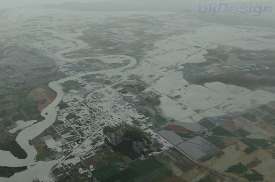
Aerial computer generated
depiction of large flood event from Burlington to Mount Vernon to Padilla Bay
Picture Courtesy Skagit
County Public Works Department
Now how hard was that? The water will go where the water has always went. As much as special purpose districts, realtors, land owners, developers, WSDOT, and city officials do not want the general public to know where the water goes, the question is easily answered with little effort and has been known for over a hundred years. (See also Map and Plans of 1936 Avon Bypass Proposal, Historical Floods Of The Skagit River (1892 through 1951), and Skagit River History)
As for the stranded fish and restoration habitat statement, what provisions for stranded fish and restoration habitat exist now when a levee breaks? The answer is that there are none. Environmental restoration does not have to be part of any particular project but must be part of an overall plan. A restoration project does not have to be “on site”. If the ETC would spend more time working on putting forward a project or series of projects, located anywhere in the floodplain (something they have not yet done), the public would be better served by their efforts instead of them trying to find fault with any and all flood projects/measures. In addition, I would be remiss if I did not once again voice my opinion on the whole “save the salmon” issue. If you were seriously concerned about saving the salmon, you would QUIT EATING THEM! Netting, selling and eating the salmon kills a lot more of them then any flood risk reduction project, with the possible exception of the building of the dams ever did. (See Historical Record of Fish Related Issues (1897-1969))
Lastly, the interior drainage issue is a legitimate one with or without any flood risk reduction project. Existing conditions demand independent measures that have yet to be developed or put forth for consideration by anyone including the U.S. Army Corps of Engineers.
Overall the ETC, like the DDTC, just doesn’t get it.
Land Use Technical Committee (LUTC)
Land Use Technical Committee comments on “emergency spillway(s)”:
1) Not enough project detail to comment on land use implications.
2) Urban and urban growth areas need to be protected.
3) Land impacted by flowage from any diversion of flood waters must be mapped and land so mapped must be protected with easements/purchase and zoning restrictions.
4) Internal drainage capacities will likely need to be increased to get rid of water one it is spilled.
5) Project should be noted as “yellow” as a concept the Army Corps or CFHMP should consider with any river by-pass project.
6) Final flowage pathway(s) must be recognized in future comprehensive land use plans to avoid intensifying development in harms way.
I have saved this committee’s comments for last because the LUTC has been the greatest disappointment in the SCFCZD AC process. They have done nothing. They have not analyzed any proposed measure, local land use regulation or the permitting process, or lack thereof of any development within any local jurisdiction. I realize that by them doing so they will be publishing a lot of Mt. Vernon’s and Burlington’s dirty laundry and land use abuse policies but the time has come for all the players to come to the table with clean hands. How can the public possibly support flood risk reduction multi-million dollar projects/measures unless the land use abuse and contempt for getting permits ends? Dike Districts must stop the filling of conveyance areas or raising their levees without permits and local governments must start complying with Federal, State and local land use regulations. They should start by analyzing the cumulative impacts of landfill placed east of Interstate 5 to determine compliance with CFR 44 §60 3(c)(10).
As was stated in the aforementioned links (See The Realities of Flood Control in Skagit County and Three Issues) the Emergency Overflow Spillway concept was put forth as follows:
Emergency Overflow Spillway: If we are successful in obtaining accurate hydraulic data and the 100 year flood flows are adjusted downward as the historic record strongly suggest they should be, and if we could achieve the added protection of additional storage either through voluntary or compensation means, then I feel that the cheapest, most environmental friendly and engineering feasible project we could build would be an emergency overflow spillway in the Avon area. This spillway would only be activated when flows reach 145,000 cfs at the Mt. Vernon gage. In the last 82 years the spillway would only have had to be used once and possibly twice (1990 and 1995). The flood waters would then flow naturally towards Padilla Bay which is where they are going to flow anyway during a major flood event. It’s not like we would be spilling the entire flow of the river. During the 1990 flood event the spillway would only have been spilling water for a period of 11 hours for an average of 5,100 cfs per hour. Granted, during a 100 year event the spillway could be spilling as much as 30-50,000 cfs but what is the alternative? To have the water flow through the City of Burlington or be forced into the Samish River Basin?
There would be many benefits to the spillway approach:
a. It would allow the flood waters to pass the City of Burlington and spill onto the floodplain in a safe manner before it reaches the City of Mt. Vernon thus saving the Urban areas from catastrophic flooding.
b. By allowing the farmland to be subject to flooding (once in the past 82 years) it would preserve the farmland from urban encroachment.
c. By designating the area as a floodway it would prohibit further development in the natural corridor where under current conditions the floodwaters are going to go anyway thus decreasing future damages. Further, it would keep the floodway designation out of the Urban areas which under current conditions in all likelihood it will be placed.
d. Out of all the projects looked at, this could be the most affordable; provide the most benefits, meet the three E’s, perhaps even be acceptable to the majority of the voters who should have the final say in any proposed project. Admittedly, the people living in this floodway corridor would object, but what they must realize is that if we do nothing, which is what we have done for the last 100 years, during any catastrophic levee failure or even if the levees hold under current conditions the water will end up in that corridor as they have in so many floods In the past.
e. What about the fish you ask? Wouldn’t providing an emergency overflow spillway put fish out onto the floodplain? The simple answer is yes. Once in the last 82 years we would have impacted some fish. In the last 82 years there have been many levee failures. The most recent on Fir Island in 1990. How many fish were impacted by the levee failures? If there were no levees, how many fish are stranded on the floodplain? The fish issue like any other adverse impact can be mitigated if given a chance.
Now from strictly a land use perspective, how hard would it be to analyze the land use implications of a concept that “would allow the flood waters to pass the City of Burlington and spill onto the floodplain in a safe manner before it reaches the City of Mt. Vernon thus saving the Urban areas from catastrophic flooding?”
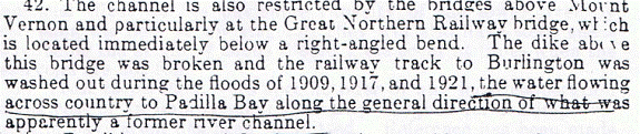
Urban and urban growth areas need to be protected. That is exactly why the emergency spillway concept was developed and would achieve. Although at the risk of stating the obvious, wouldn’t pulling back the urban growth areas and limiting development within the urban areas also contribute to flood risk reduction?
Finally the single most disingenuous statement in all the comments received: Final flowage pathway(s) must be recognized in future comprehensive land use plans to avoid intensifying development in harms way. Are you kidding me? With Burlington and Mt. Vernon being the poster children for bad land use planning within a recognized critical area/most dangerous floodplain on the west coast of America, that statement gives hypocrisy a whole new meaning. We know where the water goes (see discussion above). Skagit County, Burlington, Mt. Vernon has known for over a hundred years where the “flowage pathway” is and yet now we have reportedly 3 billion dollars in infrastructure in “harm’s way”. Where has the concern been when allowing big box stores and residential development in “harm’s way”? Clearly the LUTC just doesn’t get it and presumably by their total lack of action to date, doesn’t want to.
Most importantly, what was missing from all of the comments from the subcommittees’ was any discussion concerning the FEMA floodway designation. As stated above, the emergency spillway concept would designate the area as a floodway and would prohibit further development in the natural corridor where under current conditions the floodwaters are going to go anyway thus decreasing future damages. Further, it would keep the floodway designation out of the Urban areas which under current conditions in all likelihood it will be placed, Clearly the DDTC, the ETC and the LUTC just don’t get it.
Flood risk reduction is not rocket science. Water’s wet, it flows downhill, get the hell out of its way. What is needed in this valley are clean hands of the participants, public servants realizing they are servants not masters, and elimination of the “me first” greed concept to a solution. Sadly based on the comments received from the sub-committees on the Emergency Spillway concept, I don’t see that day coming anytime soon.
LETS DO IT OURSELVES!! LETS DO IT NOW!! LETS DO IT WITH VOTER APPROVAL!!
May your fields be ripe and budding and your rivers full and flooding (because its the only time people pay attention).
The Angry Citizen