
THE PARALYSIS OF ANALYSIS DECADE
I always look forward to the yearend editorial; however this year is a little more special than the previous years. This year represents the end of the first decade of the 21st century. Therefore, instead of concentrating solely on 2009 I thought it would be appropriate if we take a look at the last ten years of flood control/flood damage reduction/flood risk reduction efforts. As in life so as in the flood issue, many of us may not be here at the end of the next decade due to various in sundry reasons. Some will move for job opportunities, or to take care of a loved one in another state or county. Some will finally have enough of this issue and move on to other things or simply retire and some will go to that big floodplain in the sky. Whatever the reason, as I have stated many times at public presentations, “Mother Nature has left Her footprints in the sand. Walk in Her moccasins and She will show you your past and in so doing will tell you your future.” The past is wasted if we do not learn from our mistakes in order that we do not repeat them again in the future.
In order to prepare for this look back on our recent ten year
history we assembled all the documents published on this web page dated from
1/1/2000 until 12/31/2009 and put them in chronological order regardless of
their author into one document. The 92 page index document can be viewed by
clicking on the following tab
![]() .
As always, when you put documents into chronological order they tell you a
story. The 700 plus documents contained therein tell quite a story. The
editorial below is simply a historically documented look at what transpired over
the last ten years. Enjoy, but more importantly, recognize and learn from the
mistakes that were made and the opportunities missed. It’s never too late to
change direction and finally bring some common sense to this issue.
.
As always, when you put documents into chronological order they tell you a
story. The 700 plus documents contained therein tell quite a story. The
editorial below is simply a historically documented look at what transpired over
the last ten years. Enjoy, but more importantly, recognize and learn from the
mistakes that were made and the opportunities missed. It’s never too late to
change direction and finally bring some common sense to this issue.
YEAR 2000
In the beginning there was hope & promise.
The decade began with such hope and promise. Since the Skagit River Flood Control Committee had such a dismal record of accomplishment and in fact accomplished absolutely nothing, the County Commissioners put together a new committee. It was called the Skagit Risk Management Working Group (“WG”). It was comprised of Federal & State agency representatives as well as County, City, and citizen representatives. (Source: Skagit River Flood Control Committee Meeting Minutes, 6/5/2000)
The first meeting of the WG was held on July 18, 2000 and lasted for 7 hours. The meeting began with the Skagit County Surface Water Division Manager Sky Miller posing a question to the group as to how the valley had gotten itself into the current situation. He speculated that it started with the agricultural community building dikes to protect their crops. As more people moved into the area, the transportation systems in the form of highways and railroads were developed. This encouraged more people to move here. Bridges and cities sprang up and development continued. Dike building continued to the point that we are very reliant on them. Unfortunately, the dikes have a capacity that we know can be exceeded. The dikes of Skagit County can hold the water from a 25 or 35-year flood. Elsewhere, other cities have 500 year flood protection. Sky referred to this phenomenon as “flood hazard creep.” (Source: WG Minutes, 7/18/2000) It was stressed to the WG the importance of building consensus. What was needed was an effort to put a face on the 100-year event and convey the consequences of it in powerful, personal terms to key individuals, agencies, and stakeholder groups.” (Source: Design for building consensus, 7/18/2000) It is a shame that consensus was never really achieved and perhaps never will be.
One of the WG’s charges was to look at all possibilities concerning flood control or flood risk/damage reduction. Nothing was left off the table for discussion. This included but was not limited to dredging, set-back levees, overtopping, constrictions in the river. (Source: WG Minutes, 9/14/2000) (See also a most excellent Corps PowerPoint Presentation re answers to various questions presented by the WG) In just a 5-month period of time, the WG had put together a list of 17 possibilities for flood damage reduction to be considered. (Source: EI e-mail to WG, 12/8/2000) While the by-pass was gaining momentum as a potential favorite, it was not without its distracters. The USFWS was letting other federal agencies know of their dissatisfaction with the Avon By-Pass concept. (Source: US Fish & Wildlife Planning Aid Letter; Skagit River Flood Feasibility Study, 10/10/2000)
At the December 12, 2000 WG meeting the USFWS gave a formal presentation regarding their concerns about fish vs. flood control. They were pretty adamant that the only projects that benefit fish are “setbacks and ring dikes.” The urgency of the fish issue was stated as “the salmon problem is so severe that if nothing is done immediately all the fish will be lost.” (Source: WG Minutes, 12/12/2000) However there was a positive note. The United States Army Corps of Engineers (“ACOE”) announced that concerning the GI Study the ACOE will be finished with the EIS and FS in 2003 and construction is slated to begin in 2006. (Source: WG Minutes, 12/12/2000) And we all know how well that worked out for us.
YEAR 2001
When consensus is not consensus.
Although there were clearly cracks in the armor of the WG, the group did manage to narrow down their choices to just 7 alternatives. 3 variations of a Swinomish Diversion Channel; Ring Dike with selective Overtopping; Ring Dike with Overtopping; Setback Levee; Samish Diversion Channel. An excellent discussion of the pros and cons of the alternatives can be viewed at Alternatives for Analysis, 2/16/2001.
Notwithstanding the opposition from the USFWS against any of the By-Pass alternatives, it appears that the levee overtopping idea was the first to suffer the ax. (Source: County e-mail re overtopping levees, 4/20/2001) What is disturbing about the e-mail is that it shows the behind the scenes manipulation of the issues by government agencies. By April 2001, the By-pass was beginning to grow legs. However, as now, funding was a major concern. The federal government was trying to implement a tax cut, and the state was having a hard time passing a budget; neither government seems to have much money available for flood risk management projects. . . . One of the more interesting comments made at the April meeting was that the County had done a good job building in the flood plain, making many alternatives viable. (Source: WG Minutes, 4/26/2001)
That statement confirmed the belief that flood control is the prize awarded for development in the floodplain otherwise known as bad land use planning. Build enough shopping malls and roads subject to being shut down during a flood and you can justify building any flood control project. However, then like now, the government doesn’t have any money. Now unlike then, government is talking about raising taxes just to pay for government employee retirement benefits. The only way to pay for flood risk reduction projects is to either raise your property taxes or raise the sales tax and hope that a government grant comes in as matching funds. In this economic climate, I do not really see a property tax being passed by the voters.
Levee setbacks and removal of the rip-rap continued to be a major concern for the ACOE as well as other resource agencies. Overall, the group agreed that many of the benefits of setbacks would be related to the amount of riprap removed. At a bare minimum there should be no increase in the amount of riprap in the river. Mitigation measures could include additional removal. However, the cost of removing the riprap would also be a concern for the County. . . . the ACOE could not eliminate any alternatives based on cost. All of the alternatives had already been subjected to a cost-benefit analysis by the ACOE and all the alternatives were determined to be financially feasible. (Source: Second Skagit Feasibility Scoping Meeting Minutes, 5/11/2001)
More storage behind the dams was a concern to many however they were told that the “Amount of storage at Upper Baker and Ross Reservoirs had already been optimized.” (Source: Skagit River Feasibility Report Alternative Analysis, 5/22/2001) We of course now know that is not true.
By June of 2001 it is clear that government agency people were trying to manipulate the outcome of the WG. (Source: County e-mail to EI re signing document, 6/5/2001; COE e-mail to County and consultant, 6/20/2001) Major problems with the Bypass proposals were beginning to surface. The potential difficulties included water quality, water rights, saltwater intrusion, tide gates, mixing of fish stocks and maintenance of the channel. Setback levees on the other hand only had one urgent question: riprap. (Source: WG Minutes, 6/25/2001)
One more alternative was being considered at least by the ACOE if not by the WG. That alternative was a bypass from the Riverbend area to the North Fork of the Skagit and was the brainchild of the Department of Ecology. It did not meet with much enthusiasm from County employees. (Source: County e-mail to EI, 6/27/2001)
By July of 2001 the WG was just one meeting away from finalizing its work product in the form of a “Statement of Agreement”. A pretty amazing record of accomplishment considering that all this took place within just one year of their conception. The statement contained the following verbiage:
In July of 2000, over 20 people came together at the first meeting of the Skagit County Flood Risk Management Working Group (Working Group). . . . During the first phase, we brainstormed 22 flood risk management techniques to learn about. The topics that we focused on were: overtopping levees, storage, levee setbacks, dredging, dams, bypasses, and the effects of these approaches on the environment including potential effects on federally listed species and their habitat. We learned about the history, biology and hydrology of the river from local experts. We examined flood events and discussed the potential pros and cons of various flood risk management options. . . . From the perspective of those in the Working Group, the two most interesting Alternatives are: Levee Setbacks. By setting back the levees along the Skagit 1,000 feet, the river channel could hold a 100-year flood. Old riprap would be removed and the new levees would be protected by riprap and toe rock. Swinomish Diversion. This Alternative consists of a diversion channel that is 2,000 feet wide and can hold 80,000 cfs. The diversion will be either along Highway 20 or within a mile south of the Highway. The best location for a Swinomish diversion will be determined through additional studies, modeling and discussions with the Washington State Department of Transportation. (Source: WG Statement of Agreement, 7/3/2001)
It was pretty clear at that time that the Swinomish Diversion was the preferred alternative of the local people and the levee setbacks was the preferred alternative of the resource agencies. No sooner had the ink dried on the WG Statement of Agreement then the National Marine Fisheries Service (“NMFS”) in conjunction with the U.S. Fish & Wildlife Service (USFW) wrote a letter to the ACOE listing the current proposed projects for consideration by the ACOE and a list of “mitigation measures” that they expected the ACOE to enforce. The list included but was not limited to such things as 500’ buffers, rip rap removal for setback levees, no maintenance dredging, and riparian vegetation areas. (Source: Final NMFS letter to Corps of Engineers, 10/9/2001)
While it was apparent that the County was going ahead with the Swinomish Diversion, it was just as apparent that the State of Washington had grave concerns about the project. The Governor stated, “. . . any flood bypass proposal must address decisions concerning future land use of the existing floodplain, as well as design features critical for fish habitat. In addition, it must consider transportation corridors and impacts upon stream flow, existing water rights, and the Padilla Bay National Estuarine Research Reserve.” (Source: Letter fm Governor to BCC re Skagit Process for flood issues, 10/22/2001)
In a 34 page letter NMFS wasted no time in letting the ACOE and the County know that their preferred alternatives were setbacks with levee and riprap removal and overtopping levees. “The overtopping alternative is the only one that would tend to discourage development in the flood plain by its very nature, thereby making it consistent with EO 11988.” Accompanying the letter was a long list of studies they “recommended” be conducted before any flood control project could be approved. (Source: NMFS Planning Aid letter to Corps, 10/30/2001)
Skagit County in perhaps the best written effort in 100 years stood up to the federal resource agencies and wrote a letter stating the following truisms:
“The Bypass Alternative favored by the County is estimated by the ACOE to cost approximately $221 million and would displace less than 150 families with a local cost share of approximately $79 million. The Levee Setback Alternative preferred by the federal agencies has a price tag of $290 million and would displace more than 450 families with a local cost share of approximately $98 million. The increased real estate costs are a 100 % obligation of the local sponsor. This is a significant increase in both the number of local families displaced and the amount of local cost share for a rural county of our size. The Levee Setback Alternative will be analyzed during the Environmental Impact Statement; however, unless other financial partners present themselves, this option is not affordable to Skagit County.” . . . “The long list of mitigation and restoration suggested by the Agencies at this early stage indicates their unwillingness to look at this as a realistic project with budget and schedule constraints- 'We view the list as a mild form of extortion required to get agency endorsement of the project.” (Source: BCC letter to ACOE in response to NMFS letters, 12/10/2001)
Thus the battle lines were drawn. What began as a cooperative effort amongst the players quickly turned into a path of confrontation, confusion, government obstinacy, and unrealistic goals that unfortunately would set the tone for the remaining 8 years of the first decade of the 21st century and the paralysis of analysis began.
YEAR 2002
When in doubt, study it, then study it some more!
The ACOE began the third year by proposing a scope of work that analyzed 5 potential projects, 1) Bypass channel that functions for all floods larger than the 10-year event; 2) Bypass channel that functions for all floods larger than the 25-year event; 3) Setback levees with full range of events; 4) Baseline existing conditions; and 5) a take no action or catastrophic event. (Source: Revised Scope of Work for Geomorphology and Sediment Transport Study, 2/15/2002)
Skagit County in response to the 1990/1995 flood events committed to a 3.97 million dollar ACOE study and to date had spent 1.02 million dollars on the ACOE General Investigative Study (“GI Study”), and the State Department of Ecology (“DOE”) another $850,000, which was matched by another 1.22 million from the American taxpayers through the Seattle District ACOE. The new cost figures for the completion of all the elements required in the GI Study was 8.385 million. The County felt justified in the additional expenditures because the benefit to cost ratio of almost any project due to the development in the floodplain was 4 to 1. The County Commissioners’ passed Resolution #R2002010 not only authorizing the additional cost for the study but also committing to put the issue of the Skagit River Flood Protection/Salmon Restoration Project “to a vote of the Citizens of Skagit County”. (Source: County Resolution re continuing SRFS, 3/25/2002) As I have stated many times, a vote of the people is the single most important element of any flood risk reduction project.
In August 2002, I was asked by a County Commissioner to put together a table of all the flood control projects that had been looked at in the past. That table can be viewed clicking on History of Flood Control Projects Studied. As one can readily tell, the Skagit and all of its potential flood control/risk reduction projects have been looked at (i.e. studied) since 1897. Suffice it to say that there is not very much that hasn’t already been considered.
In October, the very first concerns about the hydrology the ACOE was using began to surface. Little did anyone know or expect what a powder keg of controversy this issue was about to become. From the very get-go the ACOE maps lacked creditability. It didn’t even show Mt. Vernon or Fir Island as being part of the floodplain. The ACOE explained that they had made a mistake. (Source: Memorandum - Subject: Meeting to Discuss Skagit Hydraulic Modeling, 10/11/2002) Many are willing to testify, and justifiably so, that the maps still lack creditability today.
In December, the County abandoned the Bypass as a doable project. It became very apparent that the federal resource agencies were dead set against the Bypass proposal. Tribes were killing it with faint praise, and our local cities were ambivalent at best. Those who would be most negatively affected by the floods were mostly sitting back and watching. Further, the ACOE wrote a legal decision that basically said we're toast if we don't handle the whole Padilla Bay issue with kid gloves (i.e., poor money into studies). The new approach was to get the 100-year flood through the "3 bridge" corridor, which is the constriction that exists now which will force water to jump the river east of Burlington. (Source: County e-mail killing diversion channel efforts, 12/20/2002) This approach I might add was and is one that the Angry Citizen whole heartily endorses. No other project is as economically feasible, engineeringly possible, or environmentally friendly. However, the whole concept of letting it flood once every 80 or 90 years on the farmland seems to be beyond the comprehension of those involved.
YEAR 2003
Analysis Beginning
This year began with many discussions concerning potential storage behind Upper and Lower Baker Dams. (Source: Tribal Concerns about the Reanalysis of Storage in Upper Baker , 3/7/2003; PIE Assessment of Additional Flood Control Storage at Baker River Project, 4/9/2003) “A very preliminary assessment was completed in April and has demonstrated that there could be additional flood control benefit that could be provided with additional storage at the Baker River reservoirs. However, the assumptions of the analysis need to be refined, and the proposed modifications better defined before the study proceeds to a full hydraulic and economic benefit analysis as well as undertaking NEPA scoping and environmental evaluation, as well as preparing engineering design modifications and cost estimates.” (Source: Responses to Questions Posed by Mr. Mike Sato on May 2, 2003 Regarding the Status of the Skagit River Flood Damage Reduction and Ecosystem Feasibility Study, 5/21/2003; Corps of Engineers Responses To Questions Relating to Implementation of Additional Flood Control Storage at Baker River Hydroelectric Project, FERC No. 2150, 5/30/2003; Scope of Work for Skagit River Flood Damage Reduction Feasibility Study’s Baker River Dams Storage Evaluation, 6/9/2003) Nothing of any substance was resolved with respect to the dam storage issue in 2003.
Flood analysis tables were created for the 1990, 1995, and 2003 flood events. These three flood events were the largest three floods since 1921 with the 2003 flood being the “flood of record” at The Dalles (Concrete) since the 1924 gage was installed. At Concrete, the Skagit River peaked at 42.2 feet or 14.2 feet above flood stage, which was the largest event in its 79-year record. (Source: Corps of Engineers Post Flood Report, October 2003 Flood, June 2004)
YEAR 2004
The Grinch Steals Christmas in Whoville
Although the hydrology issue had been brought up before, this year could be labeled the official start of the hydrology wars. For it was in January of this year that for the very first time in 46 years a box was opened and its contents revealed for all to see. The box contained the original work product of James E. Stewart, USGS hydraulic engineer that he performed in 1918 and 1923. It is this gentleman’s work that USGS, the ACOE, and FEMA all base their computations of the 100-year flood on. A list of the documents contained in that box can be found at Index To Stewart Documents.
A 52 page research paper was written to analyze just exactly what Mr. Stewart did in his 1923 report. The overall conclusion reached was that we should abandon his work product as Skagit County and the ACOE recommended in 1924, and utilize the 80 years of gage records we have at The Dalles. (Source: James E. Stewart Skagit River Flood Reports And Assorted Documents: A Citizen Critical Review Whitepaper , 2/14/2004; See Also Whitepaper Appendix E) I have to admit at this point that I was so naïve. I actually thought that I had done the government a favor and they would look at what I had found and realize that they had made a mistake relying on Mr. Stewarts incomplete and unfinished work product and change their figures.
At a public meeting on May 3, 2004 USGS made it pretty clear that their WSP 1527 represented the definitive USGS position regarding flooding in the Skagit River as of 1961. (Source: USGS Investigations of Floods on the Skagit River, 5/3/2004) One month later in a feeble attempt to make the Stewart issue go away USGS Tacoma Office responded with a very poor letter responding to the Stewart Whitepaper. (Source: USGS Response To Whitepaper, 6/7/2004)
Meanwhile there were other issues besides hydrology that heated up in 2004. There was actually some indication that the dam storage issue was headed in the right direction and was an achievable goal. With encouraging statements being made to the effect that dam storage “is not likely to jeopardize the continued existence of the Puget Sound Chinook salmon.” (Source: Draft Biological Opinion for Endangered Species Act, 5/28/2004) Then there was the Skagit County “Partner” in flood control efforts the Seattle District ACOE requesting “to be a cooperating agency in the preparation of the environmental documentation" of the Baker River Project, Project Number P-2150-033. (Source: Seattle District Corps of Engineers Letter to FERC, 8/9/2004) Surely having your partner doing the environmental documentation would be in your benefit especially when the County was spending 100’s of thousands of dollars on private consultants to assist in that effort. (Source: DRAFT Upper and Lower Baker Dams Probable Maximum Flood Study Report, 3/10/2004; Environmental Effects of Additional Flood Control on the Baker River, 8/11/2004; PIE Technical Memorandum: Analysis of Flood Control Storage at Baker River Project, 8/27/2004) There was even a settlement agreement that appeared on its face to provide additional flood control behind the dams. (Source: Baker River Hydroelectric Project, Comprehensive Settlement Agreement, 11/24/2004) All appeared well in Whoville. There were accolades and heckuva jobs for all. Finally, a form of responsible flood control was within reach.
However, once again, before the ink was dry on the Settlement Agreement, Skagit County’s partner, the ACOE Seattle District, sold out Skagit County taxpayers by informing FERC, "Without the completion and Congressional approval of the GI study, the Corps does not have the authority to regulate any additional storage at Upper or Lower Baker Dam." "...The Corps considers this section of Article 107 as a place holder for possible future action." (Source: Baker River Hydroelectric Project, Comprehensive Settlement Agreement, 12/21/2004) And almost by magic proclamation, the Grinch’s minions followed suit within 24 hours…"Our intent in drafting this article matches that expressed during the meeting by PSE, that Article 107 is a placeholder to show the intent of the relicense group to strive to achieve 29,000 acre-feet of flood storage at lower Baker Reservoir through the process established by the US Army Corps of Engineers (ACOE)." "Throughout the relicense process the ACOE staff has been consistent in stating that additional flood storage at lower Baker Reservoir would only be considered as part of the Skagit Basin Flood Study." (Source: Sauk-Suiattle Indian Tribe reply to FERC Comprehensive Settlement Agreement, Swinomish Tribal Community reply to FERC Comprehensive Settlement Agreement 12/22/2004) Because the additional flood storage requires several significant approvals outside of the authority of the Federal Power Act before it will become a reality, it is WDFW’s view that the proposed license language for additional flood storage is a place holder that allows for a future possibility of an action by the Corps." (Source: Washington State Department of Fish & Wildlife reply to FERC Comprehensive Settlement Agreement , 12/22/2004)
Skagit County, feeling totally sold out by its “partners” responded to FERC by stating the “Proposed License Article 107 ("Article l07') and Article 106(L) govern flood control operations at the Baker River Project for the entire term of the new license. Therefore, Article 107 is not a "placeholder," "interim," or "temporary" flood control license article, and there is no language anywhere in the Settlement that supports such a characterization.” (Source: Skagit County Government reply to FERC Comprehensive Settlement Agreement, 12/23/2004) Only the Upper Skagit Tribe seemed to “get it”. The main concern as it related to this goal from the Tribe's perspective was the effect that such storage would have on the downstream flow regime. After reviewing the proposal it was determined by all parties that the additional flood control would not have a negative impact on the proposed down stream flow regime and as such the Tribe's concerns were satisfied." (Source: Upper Skagit Indian Tribe reply to FERC Comprehensive Settlement Agreement, 12/28/04)
YEAR 2005
History becomes a player.
The year began where 2004 left off. The Seattle District ACOE’s continued its efforts of trying to ensure that additional flood control would not become an achievable goal. The ACOE threatened FERC by stating, “If FERC includes the addition of 29,000 acre-feet of storage at Lower Baker Dam as part of the license review for the Baker River Project, this would significantly complicate and delay the National Environmental Protection Act (NEPA) and Endangered Species Act (ESA) review for the license.” (Source: Corps Response to Comment Letters , 1/3/2005) What a concept, studies delaying something but it’s what the ACOE does better than anyone else so they should know.
USGS continued its efforts to justify Mr. Stewarts work. USGS had acquiesced to Skagit County’s request for an independent review of Mr. Stewarts work product by asking USGS in Colorado to review Mr. Stewarts work. It gave a whole new meaning to the fox guarding the hen house. USGS Tacoma began almost immediately to try and influence the independent review. (Source: Surface-Water Specialist Mark Mastin Letter to Skagit County Public Works Director Chal Martin, 2/10/2005) However, the “independent review” did come back with less then glowing accolades for Mr. Stewarts work. “Stewart’s study of historical floods in the Skagit River basin had, by today’s standards short-comings, simplifications, incomplete documentation, no known photographic documentation, and took decades to review and complete the evaluation of flood hydrology for the Skagit River near Concrete.” Further, the report stated, "I believe much of the uncertainty in the historical flood estimates that can be evaluated now resides in factors that likely may remain unknown (unless someone can find newspaper records, diaries, or other historical documents) and need to be evaluated." (Source: Review & Comments of "Draft Evaluation of Flood Peaks Estimated by USGS" by Robert D. Jarrett, Ph.D., USGS, National Research Program, 2/14/2005)
Really? Newspaper articles? How ironic. The same day Dr. Jarrett authored the above USGS letter a presentation was being given to the Skagit County Commissioners regarding historical newspaper articles. 2005 was the year that historical documentation began to “grow legs” and become a player with respect to flood issues. The Angry Citizen, his son Josef, and Skagit County’s Public Affairs Officer (a former newspaper man himself) Dan Berentson, were in the process of going through newspaper archives of the Skagit Valley Herald, Burlington Journal, The Courier Times, The Argus and later the Concrete Herald. A public presentation was given to the Skagit County Commissioners on the status of the research efforts. (Source: Presentation to Skagit County Commissioners on Historical Newspaper Articles 1895-1969, 2/14/2005) It was decided that work product, a labor of love, should continue. It is my belief that the newspaper articles along with other historical documents clearly show Mr. Stewarts work product to be unreliable at best, and a complete fabrication at worst. A historical flood paper was prepared using the newspaper articles reviewed at that time. (Source: Historical Floods Of The Skagit River (1892 through 1951) , 5/15/2005) During May of 2005 the historical web page www.skagitriverhistory.com was created. Currently there are over 3000 newspaper articles, government documents, studies, public hearing transcripts, letters, memos, e-mails, etc. archived and electronically preserved for future generations. Many of the articles, documents, and studies deal directly with the “Stewart flood estimates”.
In August 2005 USGS issued its long awaited Verification of 1921 Peak Discharge at Skagit River near Concrete, Washington, Using 2003 Peak‑Discharge Data report. (Source: USGS Scientific Investigations Report 2005–5029, 8/1/2005) USGS, based on this report, decided not to change the four controversial historical flood event discharges (1897, 1909, 1917, & 1921). This report will later be described as such a poor work product that it was unfortunate that it was ever published at all. Two years will pass and USGS will revisit this issue.
The cost of flood studies continued to escalate. Including the cost associated with the ACOE GI study and the FERC relicensing of the Baker Dams the County had spent since the beginning of the decade a total of $6,458,988, of which $2,007,988 came directly out of County taxpayer pockets. (Source: Annual Expenditures on Flood Study, 4/12/2005)
YEAR 2006
Vitriol was the only work product.
The County’s consultant Pacific International Engineering (“PIE”) in December 2005 prepared a document titled “Hydrology and Hydraulics, Skagit River Flood Basin – Existing Conditions”. The report was best described as a summary of the results of eight different reports previously prepared by PIE. FEMA asked its hydraulic consultant the Michael Baker, Jr. Engineers Corporation to review PIE’s work. The review came back and it could be said that it found PIE’s work product somewhat unsatisfactory. In summary, it stated:
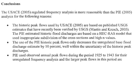
(Source: An Evaluation of Flood Frequency Analyses for the Skagit River, Skagit County, Washington, 2/10/2006)
As I started this look back at the last decade, I stated that documents in chronological order tell you the story. I have always wondered why the terrible reception we experienced from the ACOE and FEMA in Washington DC when the effort put forth was pure and sincere and truth was the only motivator. (See James E. Stewart Work Product Goes to D.C. , 3/7/2006, and DC Trip Experience, 4/24/2006.) The answer is clearly that they and our legislative aides had Michael Baker’s response to PIE’s work product and their minds were already made up. They had no response from PIE to the Michael Baker analysis. However, PIE eventually did respond in November. (Source: PIE response to Evaluation of Flood Frequency Analyses, 11/20/2006) Unfortunately, an opportunity delayed is often an opportunity missed and by November, no federal agency was listening to PIE or their supporters any longer.
Despite what may have been happening from the so-called experts in the hydrology field, from a historical perspective the Stewart figures were again being drawn into question. A pioneer family member who grew up in Hamilton and local well respected newspaper man, Fred Slipper, provided a declaration that confirmed the belief that not all homes in Hamilton suffered water damage even in the now infamous 1921 flood event which was reported locally as the largest flood event ever experienced by the locals. (Source: 12/22/21 CT, 12/24/21 C.H. 12/31/21 C.H.) The “Smith House” had no water in it in 1921. Mr. Slipper’s house only had a couple inches of water in 1921. In 1990, it had 16 inches. (Source: Declaration of Fred W. Slipper, 5/7/2006)
After two years of additional research the Stewart Whitepaper, was Updated and Republished . The document swelled from its original 52 pages to 90 pages. The paper concluded that the reasons the Stewart data should be rejected included but were not limited to: It doesn’t conform to local history; the report was in conflict with Stewart’s own handwritten notes and field notebook; WSP 612 (1929) and WSP 1527 (1961) both use Stewart’s 1918 and 1923 data. (You can’t get to the 1923 figures by using the 1918 data.); Reports (1923 and 1961) were never completed; Stewart was paid directly by Skagit County not USGS (Skagit owns his work product not USGS); Stewart nor anyone from USGS took measurements between Baker River and The Dalles (a distance of 2.5 miles not the 1 mile Stewart reported); Stewart’s work product rejected by ACOE in 1924 and 1951; Determination of “N-factor” at Sedro-Woolley inappropriate for The Dalles something Mr. Stewart himself was concerned about. Surely, with this additional historical information, much of which came from local newspaper articles and other historical documents that were requested by USGS themselves (Source: Robert D. Jarrett, Ph.D., USGS, National Research Program, 2/14/2005) they would have to change their stance on the Stewart hydrology. Not only did USGS not change their minds, they did not review the entire document and they made it pretty clear that pompous academia had made the decision not to change the Stewart figures no matter how incomplete or questionable Mr. Stewarts work product was. In fact, admissions by USGS made anything they say anymore highly subject to suspicion with respect to accuracy. Quoting from their response, “uncertainty is a fundamental part of hydrology, science, and engineering”. (Source: USGS Response to Updated Whitepaper, 10/26/2006) Think about that the next time you drive across a bridge. For people that say they rely on historical records, they seem to be masters at ignoring it especially when their version is not true.
2006 was a very volatile year with many confrontations between FEMA and the local governments mostly concerning the impacts of the hydrology on the Flood Insurance Study (“FIS”) maps. It was felt locally that from FEMA’s perspective, the difference in hydrology is not significant in that it will not affect the downstream flood elevations much whether the 100-year event is 174,000 cubic feet per second (County hydrology), or 230,000 cubic feet per second (COE hydrology). (Source: SRIP Executive Committee Minutes , 2/16/2006) However, what it will impact is the size and cost of a flood project that will be necessary in order to contain the “hypothetical” 100-year flood event should containment be the project that local government chooses and from personal experience it appears that is the only kind of project that the locals will entertain. In PIE’s own words “we can manage a flood flow of 174,000 cfs but not the 235,000 cfs that the Corps and FEMA estimate. " (Source: SRIP Executive Committee Minutes , 2/16/2006) In August, FEMA Representative Carl Cook stated, “FEMA would consider any data provided by the cities or SRIP” (Skagit River Impact Partnership). (Source: Executive Committee Minutes, 8/17/2006) Then FEMA dismisses Mt. Vernon’s concerns over the consultation process required by law. (Source: FEMA letter to Mt. Vernon Mayor Bud Norris, 9/29/2006) Further, FEMA reneges once again on its commitment to review documentation concerning the correct hydrology for the Skagit River. (Source: FEMA letter to Skagit River Impact Partnership, 10/16/2006) The SRIP countered with nasty letters to FEMA Region X and the FEMA Director. (Source: SRIP letter to FEMA Region X, 11/16/2006; SRIP letter to FEMA Director, 11/17/2006)
As if a local government fighting with federal agencies and federal agencies, ignoring local governments wasn’t a bad enough scenario, local governments began fighting each other. The SRIP began to show cracks in its armor when the City of Burlington wrote a letter to the Seattle District ACOE and in the process attacked the County’s newly hired expert nhc. (Source: City of Burlington Letter to Colonel Michael McCormick, 11/1/2006)
Baker Dam storage continued to be an issue. Letters were sent to requesting more storage behind the dams. (Source: Letter to Congress re: Storage behind Baker Dams, 8/1/2006; County Commission Letters to Dam Operators, 11/6/2006) And yet another letter was sent by the Swinhomish Tribe opposing additional storage behind the Baker Dams. (Source: Swinomish Tribe letter to PSE, 10/31/2006)
Overall, 2006 was a year of vitriol on all sides of the flood issue that produced absolutely nothing but hard feelings and distrust. Unfortunately a distrust that continues today.
YEAR 2007
Who’s on first, Whats on second, I don’t know on third, USGS lowered what?
The divisions within local government continued in 2007. The County was very concerned about the SRIP’s exclusion of different interest groups and the conflicts that created for the County Commissioners. (Source: SRIP Executive Committee Minutes, 1/18/2007) Four days later the County sent a letter to the SRIP demanding that the SRIP restructure itself or it would remove itself from SRIP membership. (Source: Skagit County Commission letter to SRIP, 1/22/2007) On the same day the County sent a letter to the ACOE defending the work of their new consultant nhc. (Source: County Letter to Corps, 1/22/2007)
The ACOE put on a dog and pony show, which among other things stated that a 100-yr “regulated” flood at Concrete would carry 235,400 cfs, Sedro-Woolley 242,000 cfs, and 230,100 cfs at the Mt. Vernon gage if the levees didn’t break. That would put the gage reading at 45.90 (the gage was at 37.3 during the 1990 and 1995 flood event). Currently according to the ACOE presentation, the levees only have a 160,000 cfs capacity. The ACOE went on to say that they would have preliminary cost for the “identified” measures costs to damages reduced figures by February. (Source: Skagit River Flood Damage Reduction Study Presentation, 1/24/2007)
At the end of February, the ACOE put on another show, this time with disastrous results. It was perhaps the ACOE staffs most embarrassing performance to date. They didn't even know the name of the Skagit Project. Staff totally rejected any more work on the hydrology issue stating flatly, "We're done with that." "We're using our hydrology." (Source: Presentation by Col. Mike McCormick to Skagit County, 2/27/2007) As of the date of the presentation, they had spent $6,600,000 and accomplished almost nothing and yet they wanted another 3-4 million dollars to complete their study over the next 5 years. By October, the estimated cost to complete the GI study had ballooned to $14,465,180. (Source: MFR for Skagit River Feasibility Study Executive Committee Meeting, 10/11/2007)
As in previous years, hydraulics was center stage most of the year. The Smith house investigation in Hamilton was made public. If Stewarts “estimates” of the early floods was correct then the Smith house should have showed several feet of water in the house. No evidence was found inside the house of floodwaters from the 1909, 1917 or 1921 flood events. (Source: Preliminary Investigation into Historic Flood Marks in the “Smith” House, 2/8/2007) FEMA applauded Burlington’s efforts to “assist” in gathering information and promised to add it to the record and evaluate the information during the 90-day appeal period. (Source: FEMA response to Hamilton Smith House Report, 2/12/2007) However, given FEMA Region X’s record of accomplishment in keeping its promises, no one is holding their breath. This was very evident when the ACOE released its Skagit River Basin, Washington Revised Flood Insurance Study - Draft Hydraulics Summary just ten days after the Smith House report was released. Further reports involving the Smith House were released later in the year all showing that the house never had water in it due to the early flood events. (Source: PIE Technical Memorandum – Smith House Flood Stages, 6/4/2007, Hromadka & Associates: An Independent Technical Review 6/7/2007, WJE Smith House Forensic Report 8/17/2007)
On August 10, 2007, USGS “Re-evaluated” the 1921 flood peak estimated by James E. Stewart. They lowered the 1921 estimated flow from 240,000 cfs to 228,000 cfs. (Source: Re-evaluation of the 1921 Peak Discharge at Skagit River near Concrete, Washington, 8/10/2007) There are those who would say I should be very pleased that the efforts of a layperson contributed to making the federal government blink and change what they had so adamantly stated they would not change. To some degree, I could take some satisfaction in that if it was not for the fact that there is an overwhelming body of evidence that supports even lower figures.
In addition to the Smith house not supporting the Stewart figures, another location in Skagit County also began to beg that Stewart’s figures were askew. That location was the Crofoot Addition subdivision in Concrete, adjacent to the Baker and Skagit Rivers. (Source: Preliminary Historical Investigation of East Concrete and Crofoot Addition Flood Levels, 11/17/2007) Stewart spent a lot of time in the Concrete area and many of his computations at The Dalles were based on information he relied on in Concrete adjacent to the Baker River.
Despite the ACOE show of arrogance and contempt for the local concerns about hydrology, Skagit County continued its studies with nhc. nhc determined "an estimated 100-year peak “unregulated” discharge for the Skagit River near Concrete" at The Dalles should be "of between approximately 240,000 and 250,000 cfs, compared with the current estimate of 284,000 cfs". (Source: nhc Skagit River Hydrology Independent Technical Review , 4/1/2007) Ironically, given all the heartburn and consternation over the hydrology issue, only two individuals commented on the nhc presentation. Not surprisingly, one of those is writing this editorial. (Source: Analysis of the NHC Skagit River Hydrology Draft Report, 4/15/2007) Over the course of 2007 nhc would prepare several analysis for the County, all of which justified lower figures for the early flood discharges arrived at by Stewart. (Sources: nhc Review of Skagit River Basin Hydrology Draft Report Existing Condition by PIE, 11/1/2007, Interim Review of US Army Corps of Engineers Lower Skagit River Flo-2d Model by nhc 12/202007)
FEMA put on its own version of a dog and pony show concerning the new FIS rate maps. You had to feel sorry for the FEMA representative who in real life is a really nice guy but the whole community seemed at times to be yelling at him. FEMA was using a 100-year “regulated” discharge at Concrete of 226,400 cfs, which was 9,000 cfs (almost 1 foot) lower, then the ACOE was using which is a little disconcerting considering the same hydrologist was doing both studies. The 90-day appeal period was estimated to start in September 2007, which would have made the maps effective in July 2008. (Source: FEMA 2007 Skagit County Outreach PowerPoint Presentation, 5/15/2007) Once again, we all know how well that worked out. The impacts of the new BFE figures would be substantial to existing development with 5.7 feet of water in the Cascade Mall, a facility that when built was told it built to 1 foot above the BFE. (Source: Examples of Deepest Flooding in Mount Vernon and Burlington, 5/24/2007)
Discussions began concerning the Skagit Countywide Flood Control Zone District (“SCFCZD”). (Source: Skagit County Flood Control Committee Minutes, 3/5/2007) A “rough cost estimate” chart for a handful of local projects county staff thought the District should look at surfaced and showed a $267,942,165 price tag. (Source: Public Works Dept. Memo re Rough cost estimate for FCZD planning purposes., 4/24/2007) The memo would later be revised and the new price tag came in at $262,656,298. (Source: Update to planning memo, 5/3/2007) Once again, county staff shows its contempt for the voting public by not wanting voters to vote on a property tax to support the SCFCZD. (Source: Comments on FCZD presentation, 5/21/2007, Public Works Draft Strategy for Skagit River Flood Control, 7/5/2007) Staff did give a very good presentation on the organization and funding options for the SCFCZD. (Source: Flood Control Funding Options, 6/4/2007) However, they did leave out any meaningful discussion of a sales tax, which prompted an alternative to the SCFCZD. (Source: Plan B Presentation to Skagit County Commissioners, text version, Presentation to Skagit County Commissioners, Re: Plan B video version, 6/26/2007) While the alternative was not accepted, the sales tax option is still alive and hopefully will be the preferred alternative of the voters. For an inside look at the history and the development of the countywide flood control district through the use of historical documents and e-mails by county officials please refer to SKAGIT COUNTYWIDE FLOOD CONTROL DISTRICT – AN EVOLUTION IN PROGRESS.
YEAR 2008
“Wonky” Things
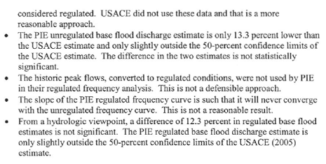
As mentioned in 2007 the Crofoot subdivision became a focal point of investigation due to the fact that during the 2003 flood event at The Dalles, which is 2.5 river miles below Crofoot, the gage registered 42.21 feet, the highest recorded level since the gage was put in place in 1924. During this flood event the Sauk River had at or slightly over a 100 year event. 42.21 feet is 5.4 feet below what Stewart and USGS estimated for the Dalles in 1921. 5.4 feet or even anything over 3 feet for that matter would have put several feet of water in the Crofoot homes in 1921 (the majority of the homes were built before 1921 and many before the 1909 flood event) yet the 1921 newspaper stated there was very little damage with water only 1.5 to 14 inches in the homes. (Source: 12/17/21 C.H.) Even if we assume that it was 14 inches in the living space instead of the crawl space that still would not account for the 5.4 foot difference in the gage readings let alone the 7 foot difference in 1909. People would not have built those houses after 1909 at those elevations before 1921 had those readings been true. (Source: Why Crofoot Matters, 1/15/2008) People who live in small town America are not known to be the brightest bulbs on the Christmas tree or the sharpest knives in the drawer, but they are not stupid. They would not have built a house right next door to a house that had 5 to 7 feet of water in it just a few years before. These are small town country salt of the earth people where in 1909, 1917 and 1921 it was not only before TV’s, computers and iPods, it was before electricity, where unlike people in the big city, they actually talked to each other. They all knew each other, walked to town together, shopped together, went to school together. Don’t you think someone would have said, “Hey, ya know that house next door to the one you are building at the same level had several feet of water in it last year.” No one ever said that because those homes never had several feet of water in them.
Local governments proposed to FEMA a 3-judge panel to make a final determination on the hydrology. Imagine that, a completely independent panel. (Source: Proposed Memorandum of Agreement (MOA) for Determining 100-year Flood Elevations, 2/1/2008) The Tribes opposed the 3-judge panel concept. (Source: Skagit River System Cooperative Letter to Ryan Ike, Re: FEMA mapping process for Skagit Valley, 2/11/2008) FEMA, not surprisingly, rejected the 3-judge panel concept. (Source: FEMA Letter to Mayor Bud Norris of Mount Vernon, Re: 3 Judge Panel, 2/26/2008)
FEMA then notifies the County that their “study contractor” the Seattle District ACOE, found problems in the FLO-2D model and the Preliminary FIS would be delayed. In addition the ACOE “recently discovered the historic data” for water years 1924 through 1944. (Source: FEMA Letter to Skagit County Commissioners, 3/27/2008) Previously they had not included those years, a criticism that sounded early in this decade.
Public presentations continued with respect to why the historical record does not support the “estimated” flood levels USGS, FEMA, and ACOE are using. One of the best graphics to illustrate why the Stewart flows did not happen in Crofoot is shown below:
(Source: Update Skagit River Flood Issues, 4/23/2008)
The USGS Stewart flood flows are not supported by local history because they did not happen to the level Stewart said they did. Simply put, Stewart made a mistake by relying on unreliable data. A mistake that we are still paying for today because of the federal government’s refusal to admit that they made a mistake for the last 87 years. Mistakes such as, “Stewart provides very few details on the nature of the high water marks in the reach below The Dalles used for the slope-area estimates. From information in his 1922/1923 field notes, the high water marks in this reach all appear to be natural indicators such as “moss scoured off of tree” (Stewart 1922/1923 field notes, page 79). There is no indication that Stewart was able to tie any high water marks in this reach into eye witness reports of flood levels. We know from experience that identification of high water marks from natural indicators one year after a flood can be quite uncertain. For example, for the same reach of the Skagit below The Dalles, the USGS had difficulty in identifying reliable high water marks from the October 2003 flood in field work conducted nine months after the event (Mastin and Kresch, 2005). In that case, the scatter in high water marks at any particular location was as much as 6 feet. We recognize that the December 1921 flood was larger than that of October 2003 and it may have left more distinct evidence of its passage. Nevertheless, uncertainty in definition of the high water marks used for the slope-area estimates should be considered when evaluating the magnitude of the event and alternative means of estimating flood magnitude should be investigated where possible.” (Source: nhc Re-Evaluation of the Magnitude of Historic Floods on the Skagit River Near Concrete - Final Report, 10/30/2008)
The County proceeded with the formation of the FCZD Advisory
Committee. The first meeting was held on June 9th. (Source:
Agenda for 1st Advisory Committee
Meeting on June 9,
5/30/2008,
Map of Possible Projects for the
Skagit County Flood Control Zone District,
DRAFT June 9, 2008 Meeting
Summary 6/9/2008)
As
previously stated, this decade began with hope and promise. It was so hoped
that this new committee would revitalize a good community effort to solving the
flood issue. Sadly, speaking as an individual member of that committee, that
has not yet happened. All of the documents reviewed and produced by the
committee since its inception can be viewed at the following link:
![]() .
.
Storage behind the Baker Dams continued to be a source of controversy. (Source: E-mail to Skagit FACT from Will W. Honea, Chief Civil Deputy, Prosecuting Attorney's Office, 6/2/2008, Scott Thomas E-mail RE: PSE, Additional Flood Storage and Corps GI Process 6/13/2008) Local governments continued to argue amongst themselves with some cities refusing to abandon the “me first” concept. (Source: Commissioners' Letter to Burlington Mayor Ed Brunz, 6/16/2008)
In the last decade (1997-2007) the cost of flood control studies averaged $1,000,000 a year for a total cost of $10,346,204. Your taxpayer dollars at work keeping public employees busy producing little if any work product. As has been shown on this web page many times there is little that these people could “study” that hasn’t already been studied. (Source: Skagit River Reports (Past studies, reports, documents, 6/23/2008)
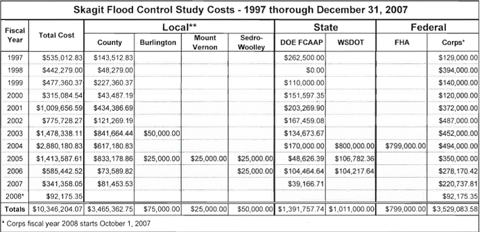
(Source: Corps and County Flood Study Cost, 8/1/2008)
The City of Burlington and it’s partner Dike District 12 announced its plans for never ending levee improvements. “The purpose is to stabilize the base flood elevations for the long term future, ensuring predictable development standards, protect the public from the 100-year flood (which has a 1% probability of occurring in any year) initially, while planning for and implementing measures to provide incrementally greater protection as time goes by.” (Source: City of Burlington and Dike District #12 Determination of Significance and Request for Comments on Scope of EIS, 8/12/2008) If there was ever a statement proving there is no such thing as a “stand alone” flood risk reduction project in a floodplain it would have to be this public announcement. The County responded, appropriately so, by stating that the “flood protection project should be evaluated holistically in a coordinated, comprehensive, and equitable manner consistent with other flood control measures being considered in the update to the 1989 Skagit CFCMP.” (Source: Skagit County Planning Comments , 8/27/2008)
The ACOE Seattle District put on its most grandiose presentation to date. They brought almost a dozen people and used a 123 PowerPoint slide presentation. They planted a sense of urgency and urged everyone in the audience to submit their questions so they could answer them right away. (Source: Skagit River Flood Damage Reduction Study Preliminary Measures Presentation, 8/18/2008) It would be almost a year before they responded to the questions. One of the first questions was how much did that meeting cost the taxpayers? (Source: Comments on Aug. 18, 2008 Corps of Engineers Presentation, 9/14/2008) The ACOE never responded to that question however it is assumed that over half of the $155,580 spent by the ACOE during July-Sept 2008 went towards that meeting. (Source: Letter to County from Corps re: financial info on GI Study, 10/31/2008) My personal opinion is that it was a classic blatant example of the wasteful expenditure of taxpayer funds by government employees. No one that I know who attended that meeting came away with anything resembling “Heckuva job ACOE” type of feeling.
YEAR 2009
The End or Just More of the Same?
Even though the federal government slightly modified its 100-year flood levels at The Dalles in Concrete, there still remained major differences in consultant vs. government figures and the hydrology issue continued to be center stage in 2009. The below table, best exemplifies the differences:
(Source: Synopsis of Skagit River Hydrology Differences Unregulated, 1/6/2009)
On behalf of the County, a final report was produced concerning the Stewart flood levels in the Crofoot subdivision. “While the current published estimate of the 1921 peak discharge is inconsistent with reported flood levels in the Crofoot Addition, we have been unable to identify the reason for such inconsistency. The currently published discharge estimate was determined by slope-area measurement. The most likely source of error in that estimate is in high water data, which were identified in the field about a year after the event. By contrast, the high water data relied on for the revisions proposed in this report are based on a newspaper account published within a few days of the flood.” The article the report is quoting from can be viewed at 12/17/21 C.H.
(Source: nhc Re-Evaluation of the Magnitude of Historic Floods on the Skagit River Near Concrete - Revised Final Report, 5/1/2009)
Despite the millions spent on hydraulic analysis, despite the historical evidence that clearly shows the Stewart flows are incorrect, the Seattle District ACOE position is “We find that the PIE and NHC investigations into High Water Marks (HWMs), survey results, and HEC-RAS modeling provide less than compelling evidence that the USGS historic flood peaks should be adjusted downward.” (Source: Memo Re: NHC/PIE investigation Recommendations, 7/10/2009)
The National Flood Insurance Program (“NFIP”) itself came under fire from of all places another federal agency. The National Marine Fisheries Service (“NMFS”) stated what I and others have been saying for years, in that the NFIP encourages and “Allows fill and levees (no insurance) and development” in our floodplains. (Source: NMFS BiOp on FEMA’s National Flood Insurance Program (NFIP), 1/22/2009) Development that all taxpayers end up subsidizing either through exorbitantly expensive flood control/risk reduction projects or through disaster relief when the projects fail and ultimately they all fail. The NFIP needs either to be completely overhauled or done away with altogether. Stop rewarding people and local governments for bad land use practices. Stop giving money for floodwalls when the local authority permits a big box store like a Wal-Mart in historically known flood areas. Flood risk reduction projects should not be the prize for hypocrisy and ignoring federal, state and local regulations.
Local governments continued their efforts and fights with the federal agencies in order that they can build more development in the floodplain of the Skagit River. Burlington publically stated that it “anticipates a substantial redevelopment of much of the City over the next 20 years.” (Source: Submission to FEMA of the City of Mount Vernon's Request for a Conditional Letter of Map Revision, 2/1/2009, Draft Environmental Impact Statement to Adopt A Strategic Program for Comprehensive Flood Hazard Mitigation in the Burlington Urban Area and Adjacent Land With A Range Of Structural and Non-Structural Components 2/13/2009, Mayor Ed Brunz Letter to Skagit County Commissioners 3/31/2009 ) So you have local governments not believing the hydrology is right, but proceeding with massive urban development anyway, which reduces the flood control/risk reduction projects to nothing more than an attempt to get around federal regulations in order to save the developers money and increase the tax base in order that Mayors can ask for higher salaries. And the taxpayers should pay for that why?
As previously stated all the documents that have been presented to
the Skagit County Flood Control Zone District Advisory Committee can be viewed
by clicking on the following link ![]() .
However, there is one document that after reviewing the documents
in the preceding paragraph, is noteworthy of mentioning now. The Dike District
Technical Sub-Committee stated the following:
“No project can reduce the existing level of
flood risk protection for a given area.” (Source:
SC FCZD Dike District Technical
Committee Meeting Agenda & Notes,
4/7/2009)
So if the cumulative effect of the Mt. Vernon floodwall and the
Burlington 100-year levee certification projects results in any other area
having their existing level of flood risk protection reduced, then neither
project can be approved according to the Dike District Technical committee.
This is why there is no such thing as a “standalone project” on a river system.
It is also why the County Commissioners are 100% correct when they stated, “The
only meaningful way to consider, analyze and balance these significant adverse
impacts on the City's neighbors is to engage in a basin-wide planning process
that involves and includes the jurisdictions and entities that are on the
receiving end of these impacts, in a manner calculated to produce mutually
agreeable, regionally applied mitigation measures and implementation
solutions.” (Source:
Skagit County Consolidated
Comments to City of Burlington / Dike District 12 Draft Environmental Impact
Statement Regarding Proposed Flood Control Measures,
3/13/2009)
.
However, there is one document that after reviewing the documents
in the preceding paragraph, is noteworthy of mentioning now. The Dike District
Technical Sub-Committee stated the following:
“No project can reduce the existing level of
flood risk protection for a given area.” (Source:
SC FCZD Dike District Technical
Committee Meeting Agenda & Notes,
4/7/2009)
So if the cumulative effect of the Mt. Vernon floodwall and the
Burlington 100-year levee certification projects results in any other area
having their existing level of flood risk protection reduced, then neither
project can be approved according to the Dike District Technical committee.
This is why there is no such thing as a “standalone project” on a river system.
It is also why the County Commissioners are 100% correct when they stated, “The
only meaningful way to consider, analyze and balance these significant adverse
impacts on the City's neighbors is to engage in a basin-wide planning process
that involves and includes the jurisdictions and entities that are on the
receiving end of these impacts, in a manner calculated to produce mutually
agreeable, regionally applied mitigation measures and implementation
solutions.” (Source:
Skagit County Consolidated
Comments to City of Burlington / Dike District 12 Draft Environmental Impact
Statement Regarding Proposed Flood Control Measures,
3/13/2009)
The 800 pound gorilla in the room that has not to date been decided by any element or participant in the flood issue is FUNDING or how ya gonna pay for any proposed flood control/flood risk reduction project? A few times it has been brought up only to be ignored by those present. “Mr. Brookings recommended exercising the existing levy authority available to the Flood Control Zone District under RCW 86.15. In addition to this source, Mr. Brookings identified county commissioner authority, under RCW 86.12, to levy a separate property tax for a River Improvement Fund, within which is a dedicated Flood Control Maintenance Account. Both of these sources are available right now in Skagit County and do not require voter approval or state legislative action as some funding sources would require (e.g. sales tax).” (Source: Local Revenue Generation for Flood Control, 5/20/2009) “If Skagit County had instituted a half-cent sales tax (.005) in the year 2005, we could have raised in excess of 42 million dollars for flood control.” (Source: Local Revenue Generation for Flood Control, 7/19/2009; Funding Options 11/16/2009) A vote on any flood project has been promised by the Skagit County Commissioners before any property or sales tax would be implemented. (Source: County Resolution re continuing SRFS, 3/25/2002; Presentation to Skagit County Commissioners, Re: Plan B 6/26/2007)
In August 2007 the ACOE put on their dog and pony show and demanded that questions be submitted to them immediately in order not to delay their responses. (Source: Skagit River Flood Damage Reduction Study Preliminary Measures Presentation, 8/18/2008) Eleven months later the ACOE responded with what can only be described as the poorest work product to ever come out of the Seattle District. The answers they provided to very real concerns by local citizens actually looked more like a lecture then definitive answers. Their responses can viewed at Corps of Engineers Response to Public Comments Made from August 2008 Meeting. Whatever happened to the “in pursuit of excellence” credo that the ACOE used to be known for? The once proud agency has lost its way.
Perhaps a fitting end to the first decade was the issuance of the FEMA FIS Rate Maps. “The Department of Homeland Security's Federal Emergency Management Agency (FEMA) has produced the DFIRM and FIS report in countywide format, which means that flood hazard information for the entire geographic area of the county, including both incorporated and unincorporated areas, is presented.” (Source: Cover Letter , and Preliminary Flood Insurance Study: Skagit County, Washington and Incorporated Areas 12/15/2009) According to FEMA Acting Regional Administrator Dennis Hunsinger, the preliminary maps revise and update information on the existence and severity of flood hazards in Anacortes, Burlington, Concrete, Hamilton, La Conner, Lyman, Mount Vernon and Sedro-Woolley, as well as unincorporated areas of Skagit County. “The study that produced these maps is one of the most comprehensive ever conducted in the Pacific Northwest,” said Hunsinger. “We used the best topographic data, revised hydrologic analyses by the U.S. Geological Survey and the U.S. Army Corps of Engineers, and the most sophisticated hydraulic model available.” (Source: Skagit County Receives Preliminary Flood Maps,, 12/15/2009) Eight days later the maps were recalled (Source: Skagit County Preliminary Flood Maps to be Re-Issued) because the maps were littered with mistakes resulting from a mishandling of data. Things like the hill in the middle of La Conner would be underwater during a 100-year-flood. Imagine that, a federal agency mishandling data. In a way, it rather made the whole decade worthwhile.
YEAR “The Future”
So there you have it. A decade in review. More than ten million dollars spent on a study. Millions more on private consultants. Heartache. Heartburn. Government pompous arrogant academia driven contempt for the history that proves their “not an exact science” wrong. Greedy, selfish urban interest trying to expand their tax base at the expense of the taxpayers. Dike District commissioners who want to flood anybody elses land but their own even though when flooding the farmland vs. flooding the urban areas saves everyone including the farmer millions if not billions of dollars.
Will this be the decade that it all ends? When close enough for government work is no longer the norm. When common sense and history guides us over greed and me first attitudes? When floodplain residents learn to live with Mother Nature and quit trying to control Her. Or will this be the decade where Mother Nature shows us all who is really in charge?
Mistakes are what floodplain residents and the government brought with them into the 21st Century. Will we learn from those mistakes or will we continue to make them? The first decade of the new century has come and gone. Nothing changed. As for as the end of the year report card, based on a review of the above, nobody passed. If you’re not part of the solution, you’re part of the problem.
I think an acquaintance of mine put it best recently when he stated, “Other than the hazard of flooding, what concerns me most is how many resources are wasted in the name of flood “solutions” and flood processes. We ought to expect more of ourselves. The flooding is an act of God. The rest, all of it; the studies, the arguing, the choices, the insurance, the requirements, the politics, the lies, mistruths, half-truths and the solutions are our own responsibilities. We shouldn’t have to pay for any more of the above than we need and we shouldn’t have to pay for mistakes others make.”
LETS DO IT OURSELVES!! LETS DO IT NOW!! LETS DO IT WITH VOTER APPROVAL!!
May your fields be ripe and budding and your rivers full and flooding (because its the only time people pay attention).
The Angry Citizen

Back to the top